It is one of the most emblematic sites in Burgundy. Perhaps the most iconic. The ROCHE DE SOLUTRÉ, classified as the Grand Site de France since 2013, stands like a majestic sphinx in the middle of the vineyards of southern Burgundy, in the heart of the Mâconnais region. Made famous by François Mitterrand’s annual pilgrimage, this beautiful natural site of Burgundy deserves you to do like the French president and climb this rock.
A unique natural site
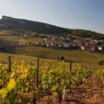
The rock of Solutré is located in the vineyards of Mâconnais. All around the rock and the village of Solutré-Pouilly lie, among others, the appellations of Pouilly-Fuissé and Saint-Véran. Two wines representative of this white wine terroir where the Chardonnay grape variety is king. These vines serve as a setting for the rock. This stone vessel rises to an altitude of 493 meters. Born from a phenomenon of rare geological erosion in the region, this limestone rock stands out in the middle of rolling and rounded landscapes, like its neighbors Vergisson or Pouilly. Before you start the climb of the rock, you can already admire it from the surrounding terrain. For photo lovers, it is probably at his feet that the Roche expresses all its greatness. From the Vergisson rock, you will also discover beautiful views of Solutré and the surrounding landscapes.
For the walk to the top of the rock of Solutré, you can park in the parking lot at its feet. The walk to the top takes about 1 hour round trip, with a vertical drop of 100 meters, and does not involve any major difficulty. At the start of the car park, a 4 km marked trail leads you to its summit. The itinerary is punctuated by reading tables that will inform you about the many facets of the place. Beware, however, the trail has many steps, so you will not be able to take strollers, bikes, etc.
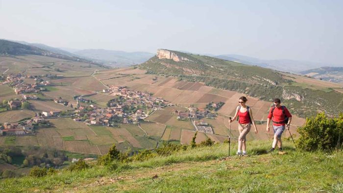
Once at the top, the view is a reward. Your gaze embraces much of the Mâconnais. The landscape is divided into a multitude of vine plots. You can also see the villages that gave their names to the appellations: Solutré-Pouilly, Fuissé, Prissé, etc. On your right, Vergisson’s rock, which rises to 485 meters, completes the picture. To fully appreciate the view, a virtual orientation table is available on the Solutré Rando app (available on Ios or Android store). It will place for you the names of the surrounding villages and natural sites. If the sky is clear, it will even point you to the Alps in the distance.


An exceptional prehistoric site
In addition to its unique geological character, the Solutré Rock is also worth discovering for its rich historical interest. This site was indeed frequented by hunters more than 55,000 years ago. It is now home to one of the richest Paleolithic deposits in Europe. A museum of prehistory was created in 1987 at the foot of the Roche de Solutré to present the results of the excavations. Or, at least, some of the results of the excavations. Much has been scattered around the world in museums such as the British Museum. This museum, buried on the side of the rock, will reveal everything about prehistory in Southern Burgundy. The museum tour is complemented by an archaeological garden and a botanical trail to learn a little more about the geology and flora around the solutré rock.


Leave a Reply